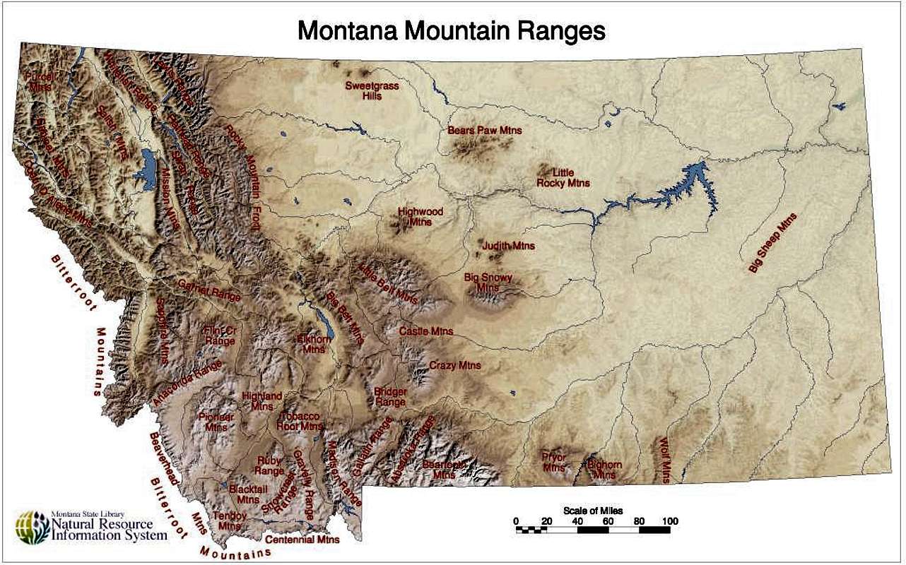
With over forty individually-named but unofficially delineated mountain ranges, Montana (from the Spanish word for mountain, montaña) is aptly named. The Rocky Mountain front cleaves down the northwestern portion of Montana, paralleling the Bitterroot, Flathead, Swan, Salish, and Mission Mountain ranges, while in the southwestern part of the state, the ranges are less of linear striations than variegated and somewhat disjointed bands of ridges jutting up like islands in the prairie.
Everyone in Montana, it would seem, recognizes the impressive Crazy Mountains; recreationalists love them for their plentiful alpine lakes, good fishing, and beautiful camping opportunities, and ranchers love them for the sweet grass they tower over. But nearby, a less known mountain range sits sentinel over a volcanic pile to the northwest.
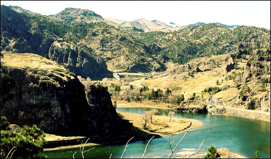
If you have ever driven on I-15 from Great Falls to Helena (or vice versa), you may remember that you pass a sign identifying the Big Belt Mountains along the highway just past Cascade. The peaks rise impressively above, and if you continue on the highway , you will drop into a section of the Missouri River canyon to the northwest of the larger peaks. The interstate crosses the river, where log cabins have been built alongside the slow moving river. You may see a historic landmark sign that tells the story of the St. Peter’s Mission, made especially famous by Mary Fields, an emancipated slave who came to live with her former owner’s daughter, a nun that had helped establish the Mission. Mary’s strength and size came in handy in the repair of the mission’s dilapidated buildings, and she became the construction foreman; but when one of the workman who resented her struck her and reached for his pistol, she fired her six-shooter at him and was asked to leave the Mission. In 1895 when she was 60 years old, she was hired as a U.S. mail coach driver in Cascade and became known as the legendary Stagecoach Mary.
Continuing past St. Peter’s Mission, the interstate meanders through dark columnar igneous rock. While this range is adjacent to the Big Belt Mountain range, it is a separate range referred to as the Adel Mountains Volcanic Field.
Both the Little and the Big Belt mountains are not necessarily impressive in the same ways as other more popular mountain ranges in Montana; they are tall, and therefore a large portion of the peaks are above timberline, but they are also not heavily forested in general and are notably more rounded. There is not exceptionally good fishing or camping available, and only one part of the mountain range, the Gates of the Mountains, is designated wilderness. The area is forest service land, and popular for off-roading and horse-packing. The adjoining Adel Mountains (eroded to be no longer a recognizable volcanic cone) provide even less recreational opportunity, being a 40 mile long by 20 mile wide swath of almost vertical volcanic rock; but they possess a fascinating and uncommon geologic history.
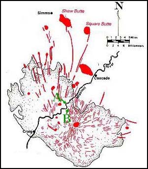
More than a billion years ago, two continental plates collided and formed what we call the Great Falls Tectonic Zone, a crustal weakness that lead to the volcanic creation of a series of mountains and buttes in the area and, most recently (around 75 million years ago), allowed magma to well up and create the Adel Mountains over top the surrounding sedimentary rock.
The Adel Mountain Volcanic Field is made of a rare type of intrusive igneous rock known as shonkinite, which is found only in Montana, British Columbia, Ontario, and the Indonesian island of Timor. It’s similar to basalt but more brittle, and principally contains augite and a type of feldspar.
From the interstate, you can see multiple dikes that radiate from the center of the formation zone; from within the canyon, the dikes are dark, vertical ridges (hint: look left at milepost 247 and right at milepost 250). These dikes often were the path magma followed to form laccoliths, which are intrusions of magma between layers of sedimentary rock that forced upper strata of rock upwards to form domes or buttes. Shaw Butte, Cascade Butte, and Square Butte were all formed in this way, and Square Butte has eroded enough to expose the actual laccolith volcanic formation within.
But you don’t need to be a historian or geologist to appreciate the Adel Mountains Volcanic Field. When I last drove through the area, the fresh layers of snow draped over the dark rock and sparkled like fish scales, and the wind picked up streams of shimmering snow and poured it over the edges of the cliffs like waterfalls. The snow crystals whirled around in the canyon and crashed against the raised road bed in the sunlight like a cold, white ocean wave, then snaked across the lanes of highway until dissipating like mist. It’s a magical area.
References:
http://www.bigskyfishing.com/Mountain-Fishing/belt_mountains.htm
http://www.cascademontana.com/mary.htm
https://docs.google.com/viewer?a=v&q=cache:8XO1-TvJs0QJ:mathscience.mt.gov/files/RoadSignPDF/Adel.pdf+&hl=en&gl=us&pid=bl&srcid=ADGEESh0lDMOJy2JJefzas4lHUc_H6eBTfZ-uxytmS7DKGQz3vl5QAAaB2u55h7R1xw2yx5uhUgLNMoSFR9hyD30XKALNUZLnKLEKzLTuigKlFTVh5d_tmO7fnp_0zY-4lukg1HmvlAc&sig=AHIEtbRRSLpC-pYQzaH3-To3SIbwOjZBIA
http://en.wikipedia.org/wiki/Adel_Mountains_Volcanic_Field
http://visitmt.com/categories/moreinfo.asp?SiteID=1&IDRRecordID=15520
 |
| http://images.summitpost.org/original/444328.jpg |
 |
| 2012 © Sara J. Call |
 |
| http://www.blackcowboys.com/maryfields.htm |
Both the Little and the Big Belt mountains are not necessarily impressive in the same ways as other more popular mountain ranges in Montana; they are tall, and therefore a large portion of the peaks are above timberline, but they are also not heavily forested in general and are notably more rounded. There is not exceptionally good fishing or camping available, and only one part of the mountain range, the Gates of the Mountains, is designated wilderness. The area is forest service land, and popular for off-roading and horse-packing. The adjoining Adel Mountains (eroded to be no longer a recognizable volcanic cone) provide even less recreational opportunity, being a 40 mile long by 20 mile wide swath of almost vertical volcanic rock; but they possess a fascinating and uncommon geologic history.
 |
| Rod Benson © http://formontana.net/hardy.html |
 |
| http://formontana.net/hardy.html |
The Adel Mountain Volcanic Field is made of a rare type of intrusive igneous rock known as shonkinite, which is found only in Montana, British Columbia, Ontario, and the Indonesian island of Timor. It’s similar to basalt but more brittle, and principally contains augite and a type of feldspar.
From the interstate, you can see multiple dikes that radiate from the center of the formation zone; from within the canyon, the dikes are dark, vertical ridges (hint: look left at milepost 247 and right at milepost 250). These dikes often were the path magma followed to form laccoliths, which are intrusions of magma between layers of sedimentary rock that forced upper strata of rock upwards to form domes or buttes. Shaw Butte, Cascade Butte, and Square Butte were all formed in this way, and Square Butte has eroded enough to expose the actual laccolith volcanic formation within.
But you don’t need to be a historian or geologist to appreciate the Adel Mountains Volcanic Field. When I last drove through the area, the fresh layers of snow draped over the dark rock and sparkled like fish scales, and the wind picked up streams of shimmering snow and poured it over the edges of the cliffs like waterfalls. The snow crystals whirled around in the canyon and crashed against the raised road bed in the sunlight like a cold, white ocean wave, then snaked across the lanes of highway until dissipating like mist. It’s a magical area.
References:
http://www.bigskyfishing.com/Mountain-Fishing/belt_mountains.htm
http://www.cascademontana.com/mary.htm
https://docs.google.com/viewer?a=v&q=cache:8XO1-TvJs0QJ:mathscience.mt.gov/files/RoadSignPDF/Adel.pdf+&hl=en&gl=us&pid=bl&srcid=ADGEESh0lDMOJy2JJefzas4lHUc_H6eBTfZ-uxytmS7DKGQz3vl5QAAaB2u55h7R1xw2yx5uhUgLNMoSFR9hyD30XKALNUZLnKLEKzLTuigKlFTVh5d_tmO7fnp_0zY-4lukg1HmvlAc&sig=AHIEtbRRSLpC-pYQzaH3-To3SIbwOjZBIA
http://en.wikipedia.org/wiki/Adel_Mountains_Volcanic_Field
http://visitmt.com/categories/moreinfo.asp?SiteID=1&IDRRecordID=15520
Shonkinite
 |
| http://www.troutfishinglodgingmontana.com/gpage8.html |