Showing posts with label Mountains. Show all posts

09 February 2015

Traveling in the Backcountry: the essentials


A cold sweat chills me from under my backpack straps. The rhythm of my ascent up the clean white mountain side hypnotizes me. Slide-clack slide-clack. My skis cut a new climbing track up the wind-drifted slope. I climb up along a sub-ridge with a friend, past twisted sub-alpine fir trees barraged by wind since germination. It's a struggle to keep grins off our faces despite the steep grade and wind-hardened snow. It's a bluebird day in the Rocky Mountains and that is hard to beat.

Exploring backcountry terrain in winter is inherently risky, so there are a few things I bring along in my backpack and in my brain to try to minimize that risk or avoid it altogether.


  • Shovel - a light and sturdy aluminum shovel is absolutely essential for a good winter backcountry kit. Not only is it necessary for digging test pits to evaluate potential avalanche hazard, but shovels are great for digging out tent pads, fire pits, and are even great to sit on if you want to stay out of the snow. 
  • Cord - bringing a length of nylon cord (4-6 mm thick, at least 10 m long) is a great idea. It's a necessary part of proper test pit procedures, can be useful in rescue scenarios and has a host of other uses.
  • Probe - it is really important to continually check the depth of the snow pack you're traveling across. Probes are collapsible, graduated aluminum tubes that can be poked down through the snow to measure its depth. They are also essential for a successful rescue in the case of an avalanche burial.
  • Avalanche beacon - always be wearing your beacon and have it turned on from the time you leave the trailhead to the time you get back. Make sure every member of your party knows how to use their beacon, and make sure to practice with them (and the rest of your safety gear) before you get into potential avalanche terrain. Keep in mind: beacons will not guarantee your safety. Do not rely on them.
  • Small repair/survival kit - you never know when gear is going to malfunction. Bindings, boots, and snowshoes can break. Bringing a small bag with a multi-tool, knife, headlamp, extra batteries, ski scraper, lighter/matches, and thermal blanket can really be a life saver--especially if you're a worrier like me.
  • Avalanche forecast - always, always, always check the avalanche advisory from your local avalanche center before you decide where you're headed, or even whether you're going out at all.
  • Knowledge and common sense - the best way to survive an avalanche or exposure in the backcountry is not to get in a bad situation in the first place! Be up to speed on safe snow travel, route-picking, avalanche avoidance, and snow science, and know the area you're going to play in. If you've never been there before, go out with or talk to someone who has.
  • A Plan - make an itinerary for your day. Write down notes or thoughts after you read the advisory, map your route if you've never been there before. Record what you see while you're out for future reference. Let someone know about your plan back home. Talk about your plan while you're out with your partners. I have found that this helps me maximize my experience in the backcountry. I don't waste time deciding where to go, and it helps me make more confident safety decisions.


We crest the main ridge. We're entering the slope a few hundred feet east at a safe entry point that's not too wind drifted.Wind blows snow into our faces. One last safety check. Boots tight, bindings secure. I watch my friend descend onto the face, a sheltered slope still clinging to some good snow. He makes arcing turns as he paints a portrait of sheer bliss.

Butterflies fill my stomach and the sun-laden snow seems even brighter. He makes it down and signals for my descent from a safe location. One last check of the boots and I roll over the edge.

07 February 2014

Friday Field Notes: Winter Gemütlichkeit

Photo: Ryan Milling
Now that Montana is back into the throes of Winter, I can postpone my pining for spring and enjoy the winter wonderland. I have not been able to look outside without being reminded of the things I truly love about the Northern Hemisphere being tilted away from the sun.

Snow is probably number 2 on my list of enjoyable frozen things (number 1, of course, occupied by ice cream). Snow affords us fantastic opportunities to enjoy nature. Skiing, sledding, snowshoeing, frolicking, track identifying, snowflake admiring...

The list goes on.

I usually like to share my experiences in wild snowy places and I always experience a distinct emotion that I feel the English language has no single word to describe. The Germans must have spent some serious time in the snowy Black Forest or Alps with their friends and loved ones to come up with this word: Gemütlichkeit. The word describes a sense of kinship and coziness but also a feeling of unhurriedness and sense of place.

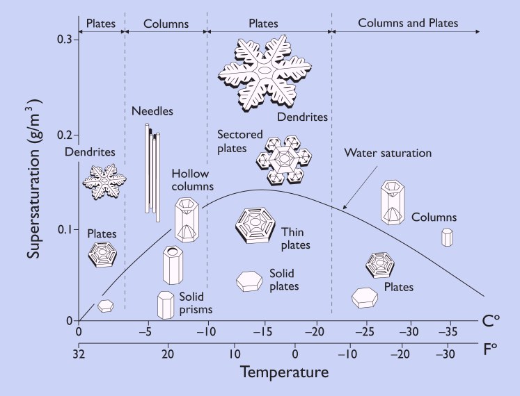
I wonder if my feeling of Gemütlichkeit this time of year is attributable to something intrinsic in snow. The birth of a snowflake takes place far above tree limbs and rooftops, their final resting places. Snowflakes form when cold water droplets crystallize around particles of pollen or dust in the atmosphere. As the ice crystals descend toward our sidewalks and ski slopes water vapor in the air crystallizes around them, forming familiar six-sided snowflakes.

The old adage goes "no two snowflakes are alike"--and that's pretty much true! The length of each arm of a snowflake is determined by its immediate environmental conditions (mainly temperature and moisture in the air: warmer/wetter = longer spindly flakes, colder/drier = shorter, more plate-like flakes). Each snowflake has minute differences in its immediate environment and so each one branches at a different point, or grows a different length, etc.
6-fold symmetry of ice crystals.

Snowflakes get their distinct 6-fold symmetry from the molecular structure of ice crystals, which is also a 6-fold symmetry. The ice crystals build on each other until the snowflake itself mirrors its molecular structure.

I suppose ultimately each individual snowflake is a collection (maybe even a companionship) of ice crystals, making a journey together towards the earth, and landing in just the right places for us to enjoy.

Photo: Ryan Milling

31 January 2014

Friday Field Notes: Chinook Winds of Fortune

On my ride into the Montana Natural History Center this morning there was one thing that was impossible not to think about: WIND. Struggling against a current of wind on an icy bike path is no cakewalk. Missoula doesn't get this windy too often, but just a handful of miles across the Continental Divide onto Montana's high plains, it's another story.

Most of Montana is occupied by rolling grasslands, once dominated by bison, pronghorn, and prairie dogs. Beautiful shortgrass prairie stretched from the flanks of the Rockies and moated the island ranges of the central and eastern parts of the state. The rich soils that sustained the plentiful life were also ideally suited for growing crops like wheat and alfalfa and stock grazing. A short time after the advent of white settlers, much of the prairie had been checkered with farms and fences, altering the pristine landscape into an anthropomorphized version of its former self.

Looking out from Square Butte towards the Missouri River Breaks
Weather, however, remains indifferent to our terrestrial tillings, not appearing to care about our comfort or chapped faces.

Wind has played an important role in Montana's history, particularly on the eastern slope of the Rockies. From harnessing wind for energy production, to dispersal of seeds and pollen for various plants, wind, despite its indifference, is critical for life on the prairie.

Chinook winds have certainly made their mark on Montana history. A Chinook wind a is warm, dry air mass that rips down the east slope of high mountains and warms the plains it crosses. Chinooks form from  westerly humid cells of air from the Pacific that dump their moisture on the west sides of mountain ranges (the great and mighty Rockies in our case), then warm adiabatically on their way back down the eastern side. The Chinook winds reach temperatures up to 60 degrees F and tear across that landscape at speeds up to 100 mph, melting and sublimating snow in their wake.
http://www.weatherexplained.com/images/walm_01_img0191.jpg
These winds are most common and severe from Cutbank to Helena, Montana. The high, steep eastern slopes of Glacier and the Bob Marshall and Scapegoat Wildernesses warm more quickly. The greatest temperature change in a 24-hour period in the U.S. was due to a Chinook wind, and occurred in Loma, Montana. The temperature went from -54 to 49 F, a 103-degree change! It is plain to see that ranchers would have relied on these remarkable weather events to make it through the unforgiving winters that punctuate every year in central Montana.

Waiting for a Chinook by Charlie Russell
As I bike back home today against that not-so-warm wind coming out of the mouth of Hellgate Canyon, I'll be dreaming of warm, dry Chinooks on the prairie.

19 October 2012

Friday Field Notes: Photo Essay: Fall in Montana


With colors of red, orange, and gold everywhere and the cool, rainy weather bearing down on us, it is evident that things are changing. Long gone are the warm temperatures and sweet (and smoky) smells of summer. It appears that sooner, rather than later, we will be immersed in a world of white. But for now, we can revel in the fact that it is Fall in Montana.


The icy cold waters of Avalanche Creek in Glacier National Park
continue to carve through ancient rock.


Aspens paint the hillsides gold near East Glacier.

A grizzly print high in the Absarokas, an indication that these creatures are moving up in elevation
to feed on critical fall food sources like whitebark pine seeds.

Rattlesnake Creek takes on many moods on an overcast day.

Much-needed moisture relieves the strain of a hot, dry summer throughout the West.

Sunlight slices through storm clouds to pit a shimmering aspen
against the backdrop of an ominous sky.

Red meets gold in the understory of the subalpine forest.

A beaver works diligently to ensure all is in place before yet another make-or-break winter arrives.

The sight of snow atop rocky peaks reminds us that winter is never too far away.


A group of American Coots gather on Lake McDonald as they prepare for winter.

28 September 2012

Friday Field Notes


The beautiful weather of late has kept me from dragging winter clothes out from the depths of my closet, and has instead forced me to continue enjoying what nature has to offer. Here's some notes, observations, and photographs from a recent trip up to Glacier National Park:

Colors across the spectrum.
Color

Fall foliage is really starting to take off. The aspens (Populus tremuloides) are shimmering gold, or are quite close to it. Plants of the understory, such as grouse whortleberry (Vaccinium scoparium) and huckleberry (Vaccinium membranaceum), fill the hillsides with shades of red and orange. Contrasted against the rich greens of conifers, the deep grays and purples of the ancient sedimentary cliffs, and the regal blues of Glacier's many alpine lakes, hiking in the park these days is like walking through a dreamland. I don't know that I have ever seen so many colors on display at once!

Bears

If you've ever been to a national park - especially one inhabited by grizzlies - you know how serious the National Park Service is when it comes to bears and safety. This time of year, the message is even more important. As bears prepare for hibernation in late summer and early fall, they enter into hyperphagia, a status literally of excessive hunger and consumption. Feeding primarily on berries, insects, and whitebark pine seeds, bears can easily consume over 15,000 calories per day. The need to constantly find more food and pack on fat leads to bears being particularly active this time of year, and as a result, increases the likelihood of an encounter with a bear. Two days in Glacier yielded three grizzly sightings, one of which was an adult male that essentially popped out of nowhere a mere fifty feet from me while hiking near Bullhead Lake in the Many Glacier valley. The other bears - a sow with her cub of the year - were observed high on a talus slope, likely digging through rocks for moths and other insects. So, to steal a line from the NPS, "Be Bear Aware" if you head out into the hills this fall.

Other Critters Abound

So you're a devoted birder and have read the passage in your Sibley Guide to Western Birds where it says golden eagles (Aquila chrysaetos) nest on rocky cliffs in mountainous areas, but you've only ever seen them on the plains or near agricultural fields. Well, that was me. Until this past weekend, when I managed to spot one soaring high near Swiftcurrent Pass, later coming to a roost on a cliff no more than one-hundred yards from the trail, allowing for a great look through binoculars. A few lucky people might get to see these massive raptors harassing young goats and sheep in an attempt to drive them off cliffs, a fascinating hunting strategy, unless you're the goat.

A young goat, not at all disturbed by my presence
Speaking of goats, there was no shortage of these fuzzy white critters in Glacier. On the Highline Trail near Logan Pass, I was lucky enough to see a ewe and her kid, as well as a lone goat up close and personal (seen to the left). Admittedly, I was a bit more excited than many of you likely are when you see a mountain goat, as this was my first time! Along with all the goats, there was a somewhat uncommon sighting of a bighorn sheep. I've seen sheep before in Wyoming as well as Montana, but this was a vintage scene: high up on a narrow ledge, traversing across loose rock, totally poised (I wish I could move across the side of a mountain like that!). It's observations like these that make you fully appreciate and understand how life has evolved to survive in some of the most challenging landscapes.


Solitude

Perhaps this photo best sums up the weekend...


Tranquility, stillness, and solitude are just some of the words that come to my mind when reflecting upon this scene. The national parks are infamous for their crowds in the height of summer, but fall is a splendid time to be gazing upon Saint Mary Lake. The hordes of people common in July and August are long gone, and one can truly experience some peace and quiet in one the most beautiful places on Earth. To be able to leave city life and the worries of graduate school behind and escape to Glacier is truly a privilege. As Montanans, we should embrace the parks, forests, wilderness, and other natural areas we have right in our backyards - the opportunities for reflection and recreation they afford us are invaluable.

I hope that you too will be able to experience Glacier or another wild place this fall. In case you can't make it out, I'll leave you with a few more photos in an attempt to share the experience! (Photos after the jump).

23 February 2012

February in the Bitterroot.

Nearly a month ago, Bitterroot Bill (the yellow-bellied marmot, cousin to groundhog Punxsutawney Phil) predicted the imminence of spring--or, more accurately, he didn't show himself at all on the overcast Groundhog Day at the Lee Metcalf National Wildlife Refuge. That may be hard to believe with all the winter storm warnings we have been getting, but we can always hope.
© Sara J. Call 2012
There's quite a bit less snow in the Bitterroot Valley, and quite a bit more sun. I drive out there every so often to get out from under the grey skies that have been frequenting Missoula Valley as of late. Even when the sky is overcast in the Bitterroot, it will open up to let rays of sun burst through, which is always wonderful. Last week, I drove down through Stevensville and took a loop through the Lee Metcalf Refuge to catch those rays of sunlight. There's a surprising amount of bird-watching to be had along the ponds, even now. Before long, I'm sure one will be able to spot a muskrat or two patrolling the thawing waterways.
© Sara J. Call 2012


Briefly, some interesting history about Lee Metcalf National Wildlife Refuge: it was founded in 1963 and renamed to 'Lee Metcalf' in 1978 in honor of the late senator that helped establish conservation projects across the state of Montana. The refuge is a total of 2,800 acres. Natural trails wind through 160 acres of ponds, sloughs, and river bottoms. While it predominately caters to providing habitat for migratory birds, the refuge also contains plenty of other creatures: beavers, muskrats, osprey, and yellow-bellied marmots, to name a few. Fish are also protected residents. The habitat is actively managed, meaning that people control water levels using siphons and pumps; provide weed control using fire, mechanical means, and sometimes cattle; and allow sportsman to come birding during hunting season. All of the management techniques are necessary to help maintain healthy wetlands and riparian areas in the refuge, where the riparian zones are human-enhanced and dependent on periodic drawdowns.


The Bitterroot Range provides a wondrous backdrop to the wetlands. I saw dozens of ducks (mallards and others) and Canada geese, and watched an American coot dabbling near the shoreline, tipping forward and bobbing with tail pointing skyward for a few moments before settling back upright on the water to swallow whatever he had found to eat. 

© Sara J. Call 2012

© USFWS Mountain Prairie


A great blue heron stood reflected in a small pond as the sun set, and the clouds were splashed with an amazing array of pink and purple that we rarely see in Missoula skies. Before I could document the moment in a photo, the heron hunched his lanky frame and lifted away into the dusk, scattering droplets of water like beads.

 In the coming months, the red-winged and yellow-headed blackbirds will return, which is my favorite time of spring. You can definitely bet on good birdwatching at Lee Metcalf NWR, year-round. 


See our spring post on the birds of Lee Metcalf from last year here.

REFERENCES:
"Get Ready For Spring" - NBC Montana, 2 Feb 2012
"Lee Metcalf Refuge Revitalizes Pond with Fire, Cattle" - 4 Nov 2011
Montana Birding Trail - Lee Metcalf NWR
USFWS Lee Metcalf National Wildlife Refuge website
Wikipedia entry

26 January 2012

The Adel Mountains: Volcanic Pile

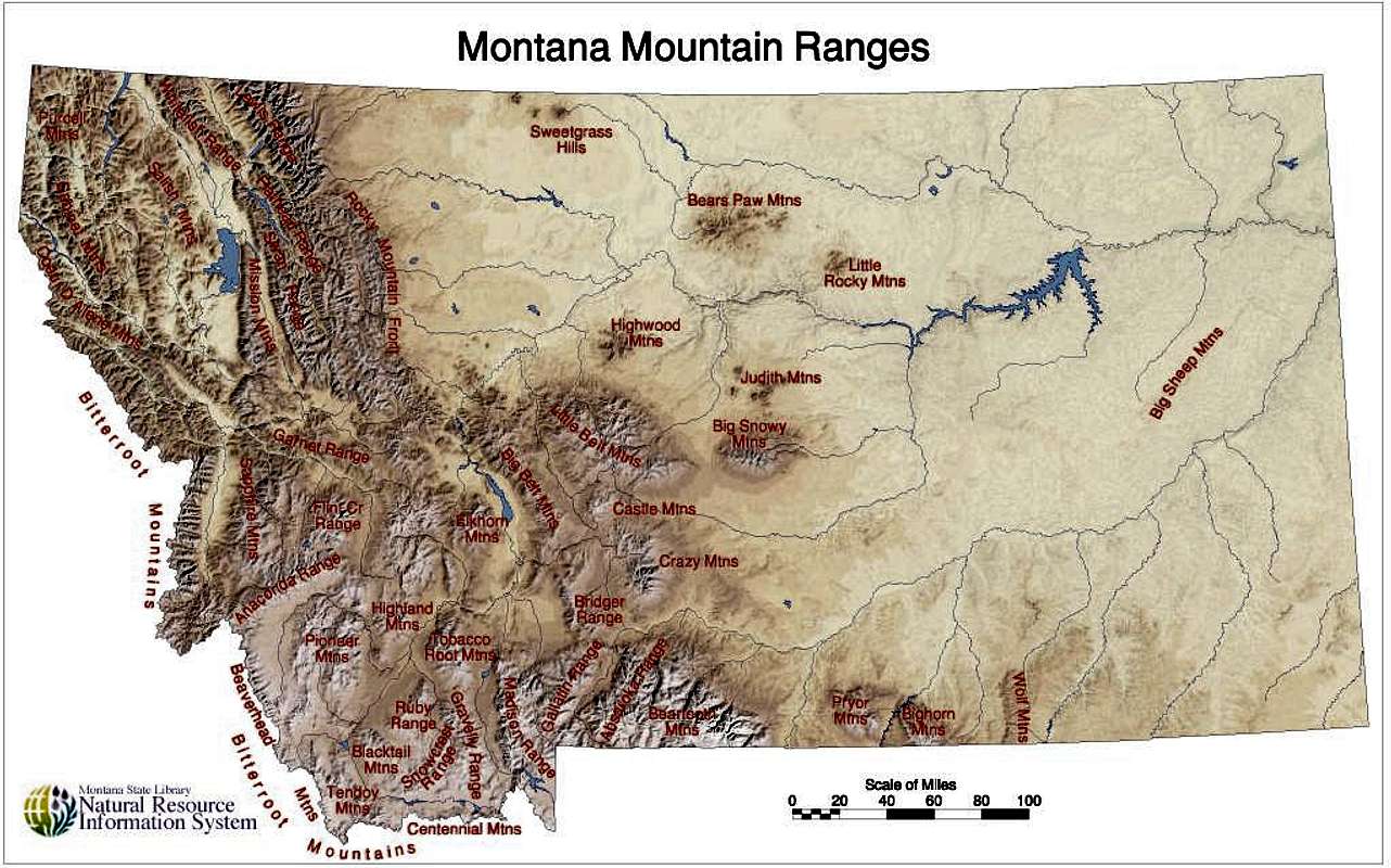
With over forty individually-named but unofficially delineated mountain ranges, Montana (from the Spanish word for mountain, montaña) is aptly named. The Rocky Mountain front cleaves down the northwestern portion of Montana, paralleling the Bitterroot, Flathead, Swan, Salish, and Mission Mountain ranges, while in the southwestern part of the state, the ranges are less of linear striations than variegated and somewhat disjointed bands of ridges jutting up like islands in the prairie.

http://images.summitpost.org/original/444328.jpg
Everyone in Montana, it would seem, recognizes the impressive Crazy Mountains; recreationalists love them for their plentiful alpine lakes, good fishing, and beautiful camping opportunities, and ranchers love them for the sweet grass they tower over. But nearby, a less known mountain range sits sentinel over a volcanic pile to the northwest.
2012 © Sara J. Call
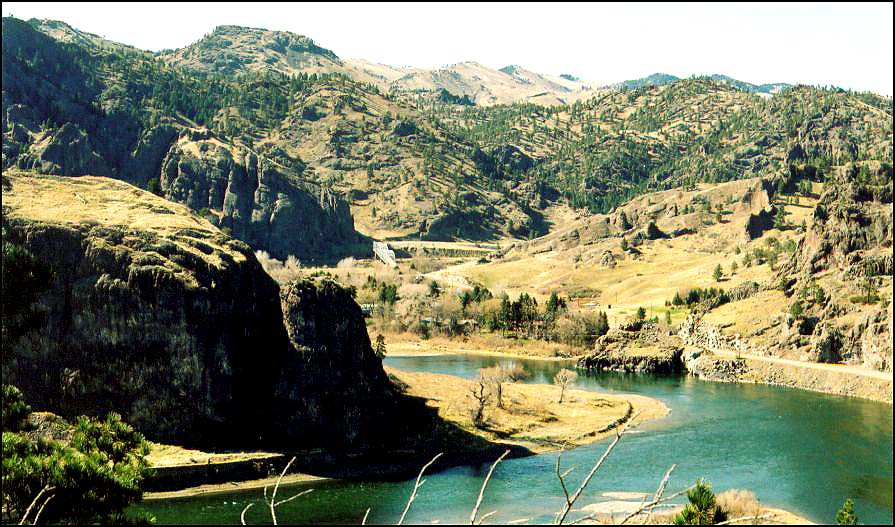
If you have ever driven on I-15 from Great Falls to Helena (or vice versa), you may remember that you pass a sign identifying the Big Belt Mountains along the highway just past Cascade. The peaks rise impressively above, and if you continue on the highway , you will drop into a section of the Missouri River canyon to the northwest of the larger peaks. The interstate crosses the river, where log cabins have been built alongside the slow moving river. You may see a historic landmark sign that tells the story of the St. Peter’s Mission, made especially famous by Mary Fields, an emancipated slave who came to live with her former owner’s daughter, a nun that had helped establish the Mission. Mary’s strength and size came in handy in the repair of the mission’s dilapidated buildings, and she became the construction foreman; but when one of the workman who resented her struck her and reached for his pistol, she fired her six-shooter at him and was asked to leave the Mission. In 1895 when she was 60 years old, she was hired as a U.S. mail coach driver in Cascade and became known as the legendary Stagecoach Mary.
http://www.blackcowboys.com/maryfields.htm

 Continuing past St. Peter’s Mission, the interstate meanders through dark columnar igneous rock. While this range is adjacent to the Big Belt Mountain range, it is a separate range referred to as the Adel Mountains Volcanic Field.
Both the Little and the Big Belt mountains are not necessarily impressive in the same ways as other more popular mountain ranges in Montana; they are tall, and therefore a large portion of the peaks are above timberline, but they are also not heavily forested in general and are notably more rounded. There is not exceptionally good fishing or camping available, and only one part of the mountain range, the Gates of the Mountains, is designated wilderness. The area is forest service land, and popular for off-roading and horse-packing. The adjoining Adel Mountains (eroded to be no longer a recognizable volcanic cone) provide even less recreational opportunity, being a 40 mile long by 20 mile wide swath of almost vertical volcanic rock; but they possess a fascinating and uncommon geologic history.

Rod Benson © http://formontana.net/hardy.html
http://formontana.net/hardy.html
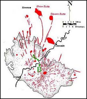
More than a billion years ago, two continental plates collided and formed what we call the Great Falls Tectonic Zone, a crustal weakness that lead to the volcanic creation of a series of mountains and buttes in the area and, most recently (around 75 million years ago), allowed magma to well up and create the Adel Mountains over top the surrounding sedimentary rock.

The Adel Mountain Volcanic Field is made of a rare type of intrusive igneous rock known as shonkinite, which is found only in Montana, British Columbia, Ontario, and the Indonesian island of Timor. It’s similar to basalt but more brittle, and principally contains augite and a type of feldspar.

From the interstate, you can see multiple dikes that radiate from the center of the formation zone; from within the canyon, the dikes are dark, vertical ridges (hint: look left at milepost 247 and right at milepost 250). These dikes often were the path magma followed to form laccoliths, which are intrusions of magma between layers of sedimentary rock that forced upper strata of rock upwards to form domes or buttes. Shaw Butte, Cascade Butte, and Square Butte were all formed in this way, and Square Butte has eroded enough to expose the actual laccolith volcanic formation within.

But you don’t need to be a historian or geologist to appreciate the Adel Mountains Volcanic Field. When I last drove through the area, the fresh layers of snow draped over the dark rock and sparkled like fish scales, and the wind picked up streams of shimmering snow and poured it over the edges of the cliffs like waterfalls. The snow crystals whirled around in the canyon and crashed against the raised road bed in the sunlight like a cold, white ocean wave, then snaked across the lanes of highway until dissipating like mist. It’s a magical area.


References:
http://www.bigskyfishing.com/Mountain-Fishing/belt_mountains.htm

http://www.cascademontana.com/mary.htm

https://docs.google.com/viewer?a=v&q=cache:8XO1-TvJs0QJ:mathscience.mt.gov/files/RoadSignPDF/Adel.pdf+&hl=en&gl=us&pid=bl&srcid=ADGEESh0lDMOJy2JJefzas4lHUc_H6eBTfZ-uxytmS7DKGQz3vl5QAAaB2u55h7R1xw2yx5uhUgLNMoSFR9hyD30XKALNUZLnKLEKzLTuigKlFTVh5d_tmO7fnp_0zY-4lukg1HmvlAc&sig=AHIEtbRRSLpC-pYQzaH3-To3SIbwOjZBIA

http://en.wikipedia.org/wiki/Adel_Mountains_Volcanic_Field

http://visitmt.com/categories/moreinfo.asp?SiteID=1&IDRRecordID=15520

Shonkinite
http://www.troutfishinglodgingmontana.com/gpage8.html