Showing posts with label Montana. Show all posts

31 January 2014

Friday Field Notes: Chinook Winds of Fortune

On my ride into the Montana Natural History Center this morning there was one thing that was impossible not to think about: WIND. Struggling against a current of wind on an icy bike path is no cakewalk. Missoula doesn't get this windy too often, but just a handful of miles across the Continental Divide onto Montana's high plains, it's another story.

Most of Montana is occupied by rolling grasslands, once dominated by bison, pronghorn, and prairie dogs. Beautiful shortgrass prairie stretched from the flanks of the Rockies and moated the island ranges of the central and eastern parts of the state. The rich soils that sustained the plentiful life were also ideally suited for growing crops like wheat and alfalfa and stock grazing. A short time after the advent of white settlers, much of the prairie had been checkered with farms and fences, altering the pristine landscape into an anthropomorphized version of its former self.

Looking out from Square Butte towards the Missouri River Breaks
Weather, however, remains indifferent to our terrestrial tillings, not appearing to care about our comfort or chapped faces.

Wind has played an important role in Montana's history, particularly on the eastern slope of the Rockies. From harnessing wind for energy production, to dispersal of seeds and pollen for various plants, wind, despite its indifference, is critical for life on the prairie.

Chinook winds have certainly made their mark on Montana history. A Chinook wind a is warm, dry air mass that rips down the east slope of high mountains and warms the plains it crosses. Chinooks form from  westerly humid cells of air from the Pacific that dump their moisture on the west sides of mountain ranges (the great and mighty Rockies in our case), then warm adiabatically on their way back down the eastern side. The Chinook winds reach temperatures up to 60 degrees F and tear across that landscape at speeds up to 100 mph, melting and sublimating snow in their wake.
http://www.weatherexplained.com/images/walm_01_img0191.jpg
These winds are most common and severe from Cutbank to Helena, Montana. The high, steep eastern slopes of Glacier and the Bob Marshall and Scapegoat Wildernesses warm more quickly. The greatest temperature change in a 24-hour period in the U.S. was due to a Chinook wind, and occurred in Loma, Montana. The temperature went from -54 to 49 F, a 103-degree change! It is plain to see that ranchers would have relied on these remarkable weather events to make it through the unforgiving winters that punctuate every year in central Montana.

Waiting for a Chinook by Charlie Russell
As I bike back home today against that not-so-warm wind coming out of the mouth of Hellgate Canyon, I'll be dreaming of warm, dry Chinooks on the prairie.

29 March 2013

Friday Field Notes: Bluebird Days

Lately, it seems as if the sky is blue more often than not. There is nothing quite like waking up to a brisk, bluebird day in the spring in Montana. The growing strength of the sunshine warms the skin and raises hope that summer is not far away. But it isn't just the sun that illuminates the landscape this time of year.

On a recent outing up Missoula's Waterworks Hill, I heard a soft, chattery whistle sound. Initially, I was caught off-guard, but rather quickly it hit me: Mountain Bluebirds. I panned around, searching for the magnificent cerulean birds, and sure enough, there they were perched on a power line right above me. I don't know why I was so surprised to see them; the sweeping grasslands are perfect bluebird habitat that the birds return to every year. Perhaps it was simply the abruptness with which they arrived. The previous day, there were no bluebirds to be found. Now, there were dozens.
A male Mountain Bluebird with his lunch.
Mountain Bluebirds (Sialia currocoides) are a small member of the thrush family, which includes common birds like the American Robbin, Hermit Thrush, Townsend's Solitaire, and other bluebirds. While common throughout Montana and most of the interior West in the spring and summer, Mountain Bluebirds move as far south as Central America to winter. Rather interestingly, Mountain Bluebirds can tolerate colder habitats than other bluebirds, and some migrate westward to the Sierras for the winter. I suppose they must be pretty hearty, as their early return to the Northern Rockies inevitably results in them being forced to weather a handful of spring snowstorms.

Unlike many bird species, Mountain Bluebirds have largely benefited from human settlement and activity in the West. The clearing of previously forested lands and the expansion of agricultural development has opened up millions of acres of new bluebird habitat. They also have been helped by our affinity for them - there must be hundreds of thousands of "bluebird boxes" scattered across the western United States.

A female Mountain Bluebird hovers while searching for insects.
Like most thrushes, Mountain Bluebirds feed primarily on insects, although their diet is supplemented throughout the year with small fruits and seeds. What sets this particular bird apart from its close relatives, however, is the way in which they sometimes acquire their food. Mountain Bluebirds can often be seen hovering in place, not unlike American Kestrels, as they scan the ground for insects. If prey is found, they quickly swoop down to the ground like a raptor pouncing on a small rodent. It is a spectacular sight to behold, made all the wilder and more intense by the bird's stunning colors.

Over the coming days and weeks, more and more of these magnificent birds are sure to arrive. Their presence on Waterworks Hill and other grassy fields across Montana is likely to be accompanied by that of a close rival, the Western Bluebird. As mating season takes off and the struggle to establish a territory reaches fever pitch, Mountain Bluebirds will clash with Westerns as well as members of their own species over nesting boxes and territories. It will be a spectacle, no doubt. I, for one, will be watching eagerly.

Have you seen any bluebirds yet this spring? Do your bluebird boxes have new residents? Be sure to let us know in the comments!

26 January 2012

The Adel Mountains: Volcanic Pile

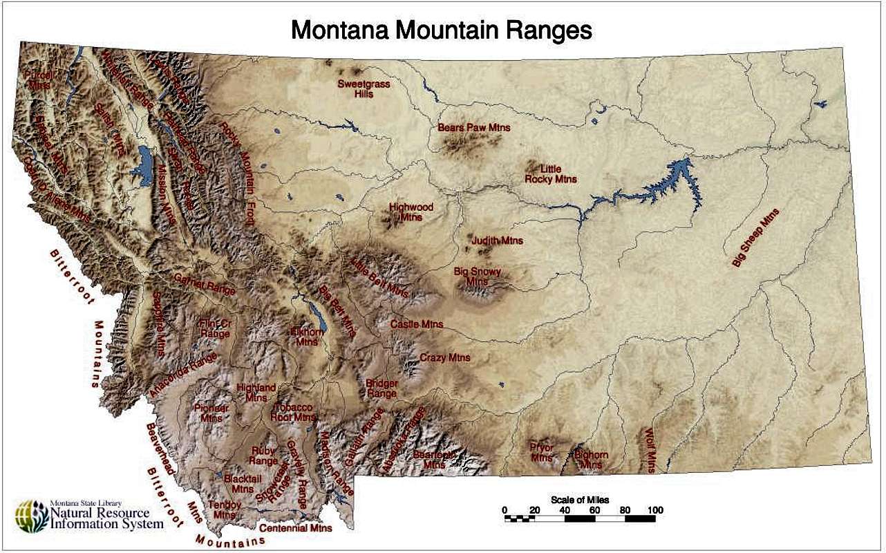
With over forty individually-named but unofficially delineated mountain ranges, Montana (from the Spanish word for mountain, montaƱa) is aptly named. The Rocky Mountain front cleaves down the northwestern portion of Montana, paralleling the Bitterroot, Flathead, Swan, Salish, and Mission Mountain ranges, while in the southwestern part of the state, the ranges are less of linear striations than variegated and somewhat disjointed bands of ridges jutting up like islands in the prairie.

http://images.summitpost.org/original/444328.jpg
Everyone in Montana, it would seem, recognizes the impressive Crazy Mountains; recreationalists love them for their plentiful alpine lakes, good fishing, and beautiful camping opportunities, and ranchers love them for the sweet grass they tower over. But nearby, a less known mountain range sits sentinel over a volcanic pile to the northwest.
2012 © Sara J. Call
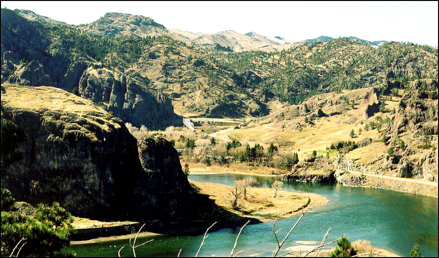
If you have ever driven on I-15 from Great Falls to Helena (or vice versa), you may remember that you pass a sign identifying the Big Belt Mountains along the highway just past Cascade. The peaks rise impressively above, and if you continue on the highway , you will drop into a section of the Missouri River canyon to the northwest of the larger peaks. The interstate crosses the river, where log cabins have been built alongside the slow moving river. You may see a historic landmark sign that tells the story of the St. Peter’s Mission, made especially famous by Mary Fields, an emancipated slave who came to live with her former owner’s daughter, a nun that had helped establish the Mission. Mary’s strength and size came in handy in the repair of the mission’s dilapidated buildings, and she became the construction foreman; but when one of the workman who resented her struck her and reached for his pistol, she fired her six-shooter at him and was asked to leave the Mission. In 1895 when she was 60 years old, she was hired as a U.S. mail coach driver in Cascade and became known as the legendary Stagecoach Mary.
http://www.blackcowboys.com/maryfields.htm

 Continuing past St. Peter’s Mission, the interstate meanders through dark columnar igneous rock. While this range is adjacent to the Big Belt Mountain range, it is a separate range referred to as the Adel Mountains Volcanic Field.
Both the Little and the Big Belt mountains are not necessarily impressive in the same ways as other more popular mountain ranges in Montana; they are tall, and therefore a large portion of the peaks are above timberline, but they are also not heavily forested in general and are notably more rounded. There is not exceptionally good fishing or camping available, and only one part of the mountain range, the Gates of the Mountains, is designated wilderness. The area is forest service land, and popular for off-roading and horse-packing. The adjoining Adel Mountains (eroded to be no longer a recognizable volcanic cone) provide even less recreational opportunity, being a 40 mile long by 20 mile wide swath of almost vertical volcanic rock; but they possess a fascinating and uncommon geologic history.

Rod Benson © http://formontana.net/hardy.html
http://formontana.net/hardy.html
More than a billion years ago, two continental plates collided and formed what we call the Great Falls Tectonic Zone, a crustal weakness that lead to the volcanic creation of a series of mountains and buttes in the area and, most recently (around 75 million years ago), allowed magma to well up and create the Adel Mountains over top the surrounding sedimentary rock.

The Adel Mountain Volcanic Field is made of a rare type of intrusive igneous rock known as shonkinite, which is found only in Montana, British Columbia, Ontario, and the Indonesian island of Timor. It’s similar to basalt but more brittle, and principally contains augite and a type of feldspar.

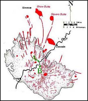
From the interstate, you can see multiple dikes that radiate from the center of the formation zone; from within the canyon, the dikes are dark, vertical ridges (hint: look left at milepost 247 and right at milepost 250). These dikes often were the path magma followed to form laccoliths, which are intrusions of magma between layers of sedimentary rock that forced upper strata of rock upwards to form domes or buttes. Shaw Butte, Cascade Butte, and Square Butte were all formed in this way, and Square Butte has eroded enough to expose the actual laccolith volcanic formation within.

But you don’t need to be a historian or geologist to appreciate the Adel Mountains Volcanic Field. When I last drove through the area, the fresh layers of snow draped over the dark rock and sparkled like fish scales, and the wind picked up streams of shimmering snow and poured it over the edges of the cliffs like waterfalls. The snow crystals whirled around in the canyon and crashed against the raised road bed in the sunlight like a cold, white ocean wave, then snaked across the lanes of highway until dissipating like mist. It’s a magical area.


References:
http://www.bigskyfishing.com/Mountain-Fishing/belt_mountains.htm

http://www.cascademontana.com/mary.htm

https://docs.google.com/viewer?a=v&q=cache:8XO1-TvJs0QJ:mathscience.mt.gov/files/RoadSignPDF/Adel.pdf+&hl=en&gl=us&pid=bl&srcid=ADGEESh0lDMOJy2JJefzas4lHUc_H6eBTfZ-uxytmS7DKGQz3vl5QAAaB2u55h7R1xw2yx5uhUgLNMoSFR9hyD30XKALNUZLnKLEKzLTuigKlFTVh5d_tmO7fnp_0zY-4lukg1HmvlAc&sig=AHIEtbRRSLpC-pYQzaH3-To3SIbwOjZBIA

http://en.wikipedia.org/wiki/Adel_Mountains_Volcanic_Field

http://visitmt.com/categories/moreinfo.asp?SiteID=1&IDRRecordID=15520

Shonkinite
http://www.troutfishinglodgingmontana.com/gpage8.html


18 November 2011

Blue Mountain Recreation Area


Last week in Missoula was filled with reasonable temps and lots of sunshine with, so I decided to seize the last nice day of fall and go to Blue Mountain for a day hike. Looking back over the wind, snow, sleet, and rain from the past week, it shows how fast seasons change here in Montana. 


Despite the temperatures in the mid-40s the sunshine really made this hike special - the view across the Missoula Valley was crystal clear. The trails were rather busy due in some part due to Veterans Day, although I think the last chance for a dry sunny day played a big part in the number of Missoulians out and about. Once I trekked further in, the crowds dissipated, bird songs audibly grew in number, and the peacefulness of the forest emerged. 


The few times I tried to catch a family of chirping birds in my view finder, the small birds kept hopping and flying away. I put away my camera and decided to just watch and listen quietly; my mental note is just as vivid in my senses as a photograph in my camera. Once satisfied with watching the fleeting birds, I kept on the path and saw a few folks in bright vests in a field off in the distance. They were working on some sort of explosives project, of which I am not sure, but it did seem strange that in the midst this beautiful public space. Later down the trail a few signs directed me to stay on the path in the marked area as there were unexploded materials in the field. This made me a little uneasy, even though I was not straying from the path, so I changed directions at the next path I found. 


I headed down closer to the river and through a more densely wooded terrain. A crow was calling loudly and it felt as if he were following my path by hopping from tree to tree as I moved forward. Not long after, the crow swooped out of the tree overhead and made a complete circle over my location of the path; I took this as a good omen for my walk. 


Not long after the crow incident, I turned back toward the parking area. The walk lasted for well over an hour, but could have easily continued for longer given time. There are plenty of trails to explore, specimens to examine, and sights to take in. 


To find Blue Mountain, head south from Missoula on Highway 93 towards Hamilton. Not long after crossing the river, there is a light at the intersection of hwy. 93 and Blue Mountain Rd., where you will take a right hand turn. Follow Blue Mountain road for a couple of minutes and after a tight turn left, you will see a parking area straight ahead and slightly to the left. Once you park your car there are many trails to choose from!

To find out more information on the recreation area at Blue Mountain please visit the All Missoula website
And, for more information on bird species and field notes from Blue Mountain please visit the Montana Birding and Nature Trail site.


27 October 2011

Philipsburg Area

 Not much more than an hour outside of Missoula, you can escape to a little morsel of historical significance known as Philipsburg. It’s not too far along I-90 E, maybe 50 miles, after you wind past the forested areas of Beavertail and Bearmouth and emerge into a wide (and golden!) valley, that you turn off the interstate at Drummond and follow MT-1 S up the valley to the small town of less than a thousand.
At this time of year, the drive from Missoula to Drummond is spectacular with all the vibrant autumn colors--red maples, yellow larch, golden aspens--but the drive from Drummond to Philipsburg along the Pintar Scenic Route is phenomenal. I love slowing down and inspecting the ranches, looking at resting horses, wandering cattle, and ranchers leaning against the fence posts.

Philipsburg isn’t that big, but don’t let that deceive you into thinking that you could see it all from one place. I stayed two days and a night, and plan on going back because I didn’t see nearly everything that I wanted to (if you’re looking for a place to stay, I would recommend The Broadway Inn).

In town, there are numerous places to eat (Doe Brothers has stellar burgers and sweet potato fries) and a decidedly amazing candy store. The Sweet Palace is overwhelming! The fudge flavors are decadent and the truffles--oh, the truffles--are worth every bite. If you happen to get there when they are packaging salt water taffies and one of the taffies escapes unwrapped, they will give you it as a sample, and you will be struck with an inexplicable desire to buy more. Just a warning.

We went up to the cemetery on the hill and sought out the oldest headstones to get a sense of the beginnings of the city. There were so many sad stories contained in the collection of grave markings, stories of children lost over the years and all at once, fathers and mothers that died young or survived decades beyond their spouses and children, singular spouses left buried in the ground alone after their partners must have packed up all they had left and moved away.

We went on a wet weekend, but after the rain let up a little, we drove the narrow dirt road to Granite ghost town. It’s a road you’ll want a high clearance, 4WD vehicle for, but it’s worthwhile heading up there.
 

Photo courtesy of Montana Fish, Wildlife, and Parks | http://visitmt.com/pictures/big/5179h.jpg
It’s difficult to believe that 3,000 people once lived where a few ruins now cling to the mountainside. We wandered along the Granite Ghost Walk and sought out foundations, most of which were broken up by tree roots and frost weathering. It’s amazing to think that the buildings in this area were built by hand, from the huge stones set in near-perfect walls to brick arches to giant steel towers. It’s amazing to think that the trees and vegetation have filled in so much in the past hundred and some years.
 
Photo courtesy of Sara Call

  The mine’s remaining structure is possibly the most impressive part of the area. It is massive, and only partially crumbling. Mica-studded granite sparkled throughout the rubble, brightened by the recent drizzle. The view from the mine’s perch was beautiful. 
Photos courtesy of Sara Call
On our second day of exploring, we made an appointment with a volunteer at the Granite County Museum and Cultural Center. Esther, a spunky older lady with lots of knowledge and hard work behind her, chatted with us but didn’t prepare us for how much we would get for our $3 admission fee. The upstairs portion of the exhibit included models, clothing, saddles, and cattle brands from way back to the 1870’s. Photos and descriptions of local ghost towns lined the walls, and an extensive mineral and rock collection filled an entire corner of a room.

We made our way downstairs, and there sat all sorts of mining equipment and buildings models--the original sign from the general store, an assay office model, a miner’s cabin, and a massive lift (the original elevator) and hydraulic engine. The absolute most incredible part of the museum was the walk-in replica of a silver mine shaft, built by volunteers. It’s a wonderful piece of work.

There are a few other ghost towns around Philipsburg that you can also visit--Kirkville and Garnet, for example--and plenty of recreational activities to engage in around the area. Over the pass to the southeast is Georgetown Lake, and if you continue down MT-1 S you’ll come into Anaconda, another town of significance in our state’s history of mining.

Of course, there’s also Drummond, which is a character-filled town in and of itself... If you’re there on a Saturday, check out the Used Cow Lot!


Sources and links:
http://visitmt.com/categories/moreinfo.asp?IDRRecordID=6737&siteid=1
http://philipsburgmt.com/museum
http://www.drummondmontana.com/SurroundingArea.html

17 October 2011

Garnet Mountain


Garnet Mountain

Last weekend I had the pleasure of meeting my brother in Bozeman for a backpacking adventure! Our destination was the Garnet Mountain Fire Lookout that is just 20 minutes south of Bozeman. The day before our trek a storm had rolled through Gallatin County and dusted the mountain tops with snow. The weather on our hike up was pleasant, in the mid-50s and only semi-cloudy. The breaks from the sun were welcomed and we cheered with cool breezes that graced our hard working bodies. The hike itself is a mere 4 miles - however you gain nearly 3,000 feet over the course of the hike.


We were cautious of bears, toting bells and bear spray, but we did not see any large wildlife during our hike. We spotted lots of Elk tracks in the mud and saw a few chipmunks scurry off the trail into the brush. We ran into snow the last quarter mile that was up to 6 inches deep in some spots. The snow made it much easier to spot animal tracks, such as some Prairie Chicken tracks, Fox tracks, and more Elk tracks.

The last stretch to the top was by far the steepest, and in the snow field a few hundred feet from the fire lookout we spotted a bunch of fox tracks zigzagging and then turned into circles. We laughed at the sight of the pattern of the tracks and wondered what the little fox had been up to, perhaps chasing his tail or more likely following a bunny, whose tracks we also found not far from the fox tracks.

The fire lookout itself was very cozy and offered unparalleled views of the Gallatin Canyon and beyond. The sunset was incredible; bright pinks, golden yellows, and blazing orange contrasted against the deep blue and bounced off scattered clouds. The views from the Lookout were well worth the aches and pains of the hike! Luckily we were not socked in with clouds or fog so we were able to take in the stars and wildly bright moon. Thanks to the snow reflecting so much of the moonlight, we were able to turn off our lantern and sit by the fire to enjoy the endless beauty below us. After inhaling a delicious fajita dinner, we were all more than ready to cozy up in our sleeping bags and call it a night.
We only stayed one night, so after waking up, eating breakfast, and cleaning up the cabin, we headed back down. It was a beautiful fall morning, full of crisp air and chirping birds. Chickadee calls were the most prevalent, however that is the bird call I know the best, so it could have been that my ear was only tuned into the Chickadees. The trek down was difficult, but beautiful and much faster than going uphill. Yet again we didn’t spot any wildlife, outside a few squirrels. This hike and Fire Lookout was amazing and will definitely be something I will do again. If you are looking for a great weekend getaway and a challenge, I would highly recommend Garnet Mountain Fire Lookout! The only thing I would do differently next time is pack along a field guide (I forgot mine at home on the coffee table, doh!)